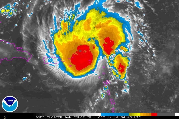
Strong rains expected from a hurricane Gonzalo
The storm became a category one hurricane yesterday. It will not touch the DR

SANTO DOMINGO. The rains caused by the cloud field of Gonzalo which yesterday afternoon became a category one hurricane, will begin to be felt this morning and will extend until tomorrow especially in the areas of the East, North East and North, however the hurricane will not touch Dominican territory.
This was a statement by the director of the National Meteorology Office (Onamet), Gloria Ceballos, during a press conference yesterday afternoon together with the directors of the Center of Emergency Operations (COE), general Juan Manuel Mendes; and Civil Defense, Major General Rafael de Luna Pichirilo.
"Hurricane Gonzalo will pass far to our East, it is forecast to be 300 km to the East of the country," noted Ceballos.
She explained that they also do not expect very significant accumulations of rain, due to the fact that the cloud bands of the hurricane are concentrated in its center and this is going to be far from the Dominican Republic and will remain in the Atlantic Ocean according to the forecast climate models.
Nonetheless, the director of the COE reported that given the risks that the rains might cause rivers, creeks and streams to overflow and cause flooding, the COE is maintaining a green alert for the provinces of La Altagracia, El Seibo, Hato Mayor, Samana and Maria Trinidad Sanchez.
He also warned small craft along the north coast to stay in port because of the abnormal waves that hurricane Gonzalo is will produce. In the meantime he called for caution when sailing along the Caribbean coast.
He asked the population to be alert for the bulletins from the aid agencies regarding the advance of this hurricane.
It will strengthen
According to the National Hurricane Center (NHC) in the United States, Gonzalo is moving with maximum sustained winds of 120 km/h and will strengthen until it becomes a category three hurricane by noon tomorrow when it will be to the east of the Bahamas out in the Atlantic.
A hurricane alert was issued for Puerto Rico, Vieques, Culebra and the US Virgin Islands.


 Argénida Romero
 Argénida Romero